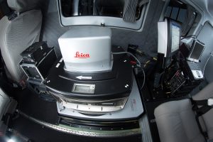
Contrary to appearances, this is not military technology, but a system enabling the inventory of flora in Polish forests. The combination of an aircraft with technologically advanced cameras and lasers was created by the OPEGIEKA company from Elbląg.
To manage the forest economy wisely you need up-to‑date information on areas occupied by trees and their specificity. This data can be acquired using remote sensing methods whereby knowledge on objects or phenomena taking place on the earth surface is gained thanks to aerial photographs, satellite images or aerial laser scanning.
OPEGIEKA has constructed a platform providing imaging and vector data which, when processed in line with algorithms compiled, will provide details on what type of plants have been scanned and photographed.
The platform consists of three elements: a twin-engine plane, an aerial scanner and a large-format camera.
Details
Beneficiary
OPEGIEKA SPÓŁKA Z OGRANICZONĄ ODPOWIEDZIALNOŚCIĄ
Programme
Smart Growth Programme
EU Fund
European Regional Development Fund
Total project value
PLN 19,870,548
EU contribution
PLN 9,640,860